-
A Site Resource Like Never Before
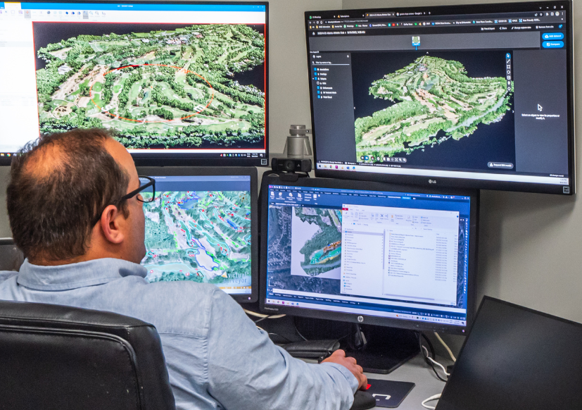
LU leads the industry in cutting-edge course mapping services affording unparalleled insights. M4 – Map, Measure, Model, Manage – is a precision modeling program that delivers high-resolution surface maps. With airborne and terrestrial technologies, we produce world-class data sets that can be used in a wide range of land development and management applications. Since its inception, we have continued to evolve our industry-leading survey techniques and software platforms to address the unique needs of our clients, affording deliverables with unprecedented accuracy and unparalleled insights. Watch our explainer video to learn more.

-
Expertise You Can Trust
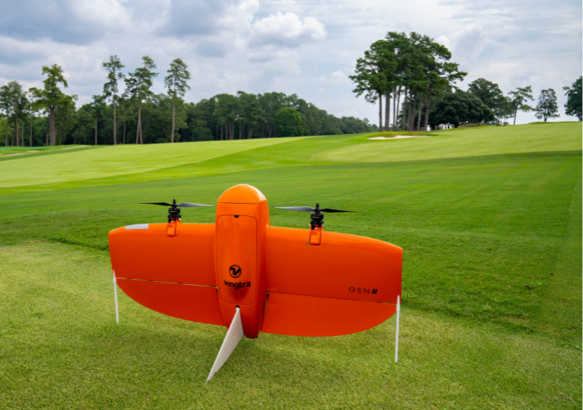
Our FAA-certified drone operators develop and execute a flight path over client properties using a multirotor or fixed-wing drone. These specially designed drones use a combination of GPS and prescribed onboard sensors to create a high-resolution aerial image and hyper-accurate surface model of the property. We use 3D laser scanners that yield sub-centimeter accuracy for areas demanding heightened levels of precision.
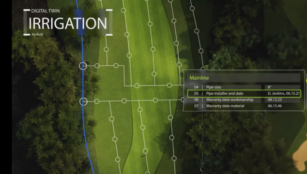
How well do you really know your property?
M4 – Map. Measure. Model. Manage. Each of the four components builds off the Map exercise in a stepwise fashion, adding value and new perspectives at every stage.
- Map – aerial and terrestrial survey captures millions of data points processed through a suite of geospatial software to produce survey-grade deliverables.
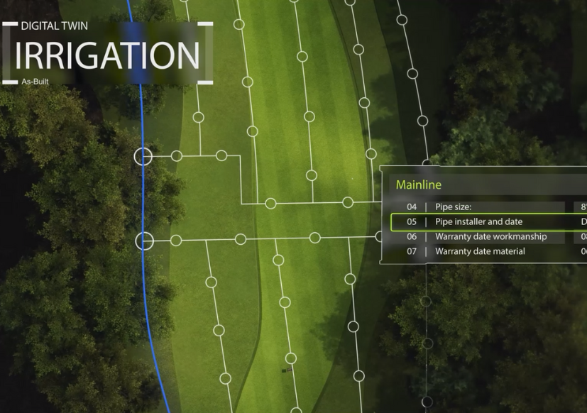
- Measure – collected data measurements include three-dimensional surface areas, material volumes, surface slopes, installed infrastructure locations, and plant health.
- Model – gain new and valuable insights that inform capital planning and operational budgets.
- Manage – leverage these new perspectives to see your property like never before.
M4 PRECISION MODELING PROJECTS
-
 M4 Explainer Video
The M4 Program gives unprecedented detail to superintendents, irrigation technicians, and anyone else who needsRead More
The M4 Program gives unprecedented detail to superintendents, irrigation technicians, and anyone else who needs hyper-accurate information on the layout of the facility. To learn more about the M4 program, please start a project, or contact Forrest King, Director of Field Technology, directly at forestk@landscapesunlimited.
M4 Explainer Video
The M4 Program gives unprecedented detail to superintendents, irrigation technicians, and anyone else who needsRead More
The M4 Program gives unprecedented detail to superintendents, irrigation technicians, and anyone else who needs hyper-accurate information on the layout of the facility. To learn more about the M4 program, please start a project, or contact Forrest King, Director of Field Technology, directly at forestk@landscapesunlimited.com. [embed]https://youtu.be/n6dp_O7cFvs[/embed] Undo
-
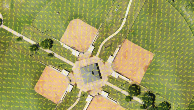
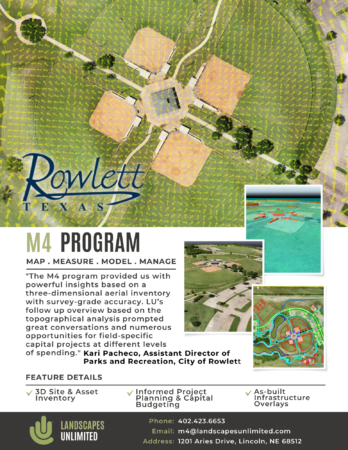
City of Rowlett, Texas | M4 Update
M4 PROGRAM MAP. MEASURE. MODEL. MANAGE "The M4 program provided us with powerful insights basedRead More
M4 PROGRAM MAP. MEASURE. MODEL. MANAGE
"The M4 program provided us with powerful insights based on a three-dimensional aerial inventory with survey-grade accuracy. LU's follow up overview based on the topographical analysis prompted great conversations and numerous opportunities for field-specific capital projects at different levels of spending." Kari Pacheco, Assistant Director of Parks and Recreation, City of Rowlett
Feature Details: 3D Asset Inventory, As-built Infrastructure Overlays, & Informed Capital Budgeting. Undo
Undo
-
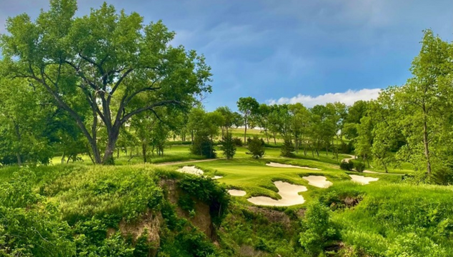
Lost Rail Golf Club
The highly anticipated 18-hole golf course was shaped from the rolling cropland overlooking the PlatteRead More
The highly anticipated 18-hole golf course was shaped from the rolling cropland overlooking the Platte and Elkhorn Rivers near Omaha. The property was the terminus of a rail line abandoned in the early 1900s. The raised rail bed still transects the property and is a feature and backdrop for several holes. Lost Rail Golf Club’s vision was to create a golf club for golfers with no swimming pools, tennis courts, weddings, public events, etc. It is not another full amenity country club but rather designed to become a world-renowned golf experience. Landscapes Unlimited has been involved with the Lost Rail project since before the land was acquired. The vision for the facility was to create a remote, wilderness-type golf experience close to Omaha, Nebraska. Just 30 minutes from downtown, Lost Rail provides members & guests with a pure golf experience close to home. The golf course components of the Lost Rail project include the 18-hole 7,300-yard course, a modern practice facility, and a seven-hole short course. From a project development standpoint, Landscapes managed:Undo
- clubhouse planning, design & construction
- halfway house planning, design & construction
- maintenance design, planning & construction
- entry road and parking grading & construction
- all associated infrastructure
- planning
- design & permitting
- construction
- membership sales & marketing